Across the world, major river basins are the economic engine of communities. They are essential for agriculture, industry, transportation, power production, and water supply—but all of these depend on a community’s ability to predict the rivers’ flow. Forecasting the annual and seasonal variability of water resources is essential for accurate assessments of water availability, as well as for planning for extreme hydrological events such as of floods and droughts. However, observations of water in many developing countries are constrained by lack of adequate gauge stations. In addition, many agencies that collect streamflow or precipitation data are not likely to share this data internationally due to national security policies of their respective governments, which makes comprehensive analysis very difficult. It is here that satellite remote sensing and use of global land model data sets can help.
This blog post focuses on the basin of the Ganges and Brahmaputra rivers. I will give examples of how satellite remote sensing can be used over large areas and long time periods to identify spatial and temporal variation, as well as to estimate total water fluctuations using a simple water balance model. I will also discuss how to compare hydrologic phenomena across regions.
The Ganga Brahmaputra basin is shown in Figure 1. It is about 1.5 million square kilometers in area and has a tropical monsoon climate with an average annual rainfall of 39–200 cm and an annual average air temperature of 73 F (23 oC). The basin’s water source is glacial meltwater, especially in dry seasons. This river basin is home to over 600 million people, and the main land use is agriculture. Millions of years of erosion of the Himalayas have resulted in fertile alluvial soils.
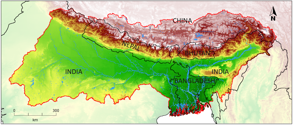
Figure 1. Ganga Brahmaputra river basin.
Numerous studies have shown the impacts of climate change and population growth on water resources (Arnell, 1999; Alcamo et al., 2007; Kundzewicz et al., 2007; Oki and Kanae, 2006; Piao et al., 2010; Ragab and Prudhomme, 2002; Vorosmarty et al., 2000). Others have focused on the very specific impacts of a changing climate on, say, groundwater recharge under various climate-change scenarios (Herera-Pantoja and Hiscock, 2008; Scanlon et al., 2006; Taylor et al., 2013). One conclusion common to such studies is that the global per capita water availability is decreasing, as a result of both climate change and an increasing population. This is of particular concern in the Indian subcontinent, especially in the Ganga Brahmaputra basin. Vorosmarty et al. (2000) and Oki and Kanae (2006) have calculated high water scarcity indexes in the western United States, northern Africa, South Asia, and the Middle East regions. They have shown that the relative demand for water will likely increase with the changes in climate and population especially in river basins including the Colorado, Nile, Mekong, and Ganga Brahmaputra.
In addition to an inadequate water quantity, water quality is a serious concern in the Ganga Brahmaputra river basin. The river is essential to the water and food security of half a billion people. As a result, cleaning and rejuvenating the health of the Ganges river ecosystem is the focal point of river basin management plans such as the “National Mission for Clean Ganga” (http://nmcg.nic.in/). In order to clean the river, chemicals entering the river through point- and nonpoint-source pollution should be constrained. While point-source pollution can be easily identified and remedial actions can be taken, nonpoint pollution is difficult to quantify and mitigate.
Predicting Nutrient Loads
The macronutrients nitrogen (N) and phosphorus (P) enter the river system primarily through nonpoint sources (Howarth et al., 2000). These elements are essential for biologic growth in aquatic environments, yet their overabundance can create environmental problems including overgrowth of N- and P-fed algae, deteriorating water quality, and destruction of aquatic life. N and P contamination of rivers happens through the discharge of industrial and municipal wastewater into the river and the extensive use of fertilizers on agricultural land (Tilman et al., 2002; Ritter et al., 2002). While direct industrial and municipal sewage discharges into the river can be limited by implementing “zero liquid discharge” to the river, N and P sourced from fertilizers are difficult to constrain when they enter the riverine system via groundwater discharge (base flow) and surface runoff (Schilling and Zhang, 2004).
N and P contamination of water bodies in the Indo-Gangetic plain is a growing concern, since consumption of N- and P-based fertilizers has increased by more than 30% over the last 10 years (http://urvarak.co.in). However, studies of the effects of agricultural nutrients on water quality in the Ganga Brahmaputra river basin are lacking. There are numerous small, rain-fed rivers in the Indo-Gangetic floodplain that flow predominantly through agricultural land. They are an important nonpoint source of N and P. Studying those small floodplain rivers is important as they may provide local managers with a clearer understanding of how increasing the rate of use of N- and P-based fertilizers will drive N and P pollution of larger rivers in future.
Preliminary results demonstrate that the runoff from such small floodplain rivers is an important process that controls the dissolved nutrient load of large river systems, and hence affects the quality of water. Data from the Pandu River, a small tributary of the Ganges that predominantly flows through an agricultural watershed, shows that such rivers carry a substantial load of Dissolved Inorganic Nitrogen (DIN flux) and orthophosphate (PO43- flux) that is most likely derived from agricultural lands (see Figure 2). The
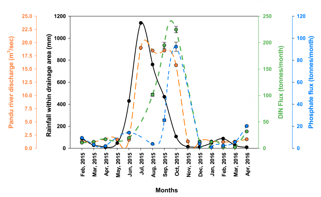
Figure 2 . Temporal changes in river discharge (orange axis), rainfall (black axis), DIN flux (green), and PO43- flux (blue axis) in the Pandu River between February 2015 and April 2016.
implication of Figure 2 is clear. Rainfall clearly leads nutrient loads, so difficult-to-obtain readings of nutrient loads can be inferred from precipitation or river discharge data that are more readily available through satellites or in-sity observations. Knowing and understanding these data and how they are linked can be very important for managing water quality.
Water Balances and P − ET − R
Previous studies on the Ganga Brahmaputra basin (Roy et al., 2015; Nepal et al., 2015; Singh et al., 2006) have been limited in scope, time, space, or water source due to lack of observational data. The studies of Rodell et al. (2009) and Tiwari et al. (2009) have demonstrated the loss of groundwater in northern India in the Ganga River basin. Indeed, to use in-situ (point-scale) observations to close the water balance of large river basins (i.e., account for all that happens to every drop of water) is difficult for a wide range of reasons. First, the water cycle is highly variable in space and time. Second, the maintenance and operation of a high-density in-situ network (like rain gauges) is very expensive and thus relatively rare. Third, obtaining data from river basins is hindered by the inconsistent collection and lack of sharing and distribution of data sets. Because of these issues, satellite remote sensing is an attractive solution that can overcome spatial heterogeneity and temporal consistency issues. Moreover, the global coverage and free public availability of satellite data can help avoid data access issues. In Lakshmi (2016), for example, we show that the Gravity Recovery and Climate Experiment (GRACE) can and should be used in a regional context, and that sub-GRACE scale variability can be explained using other satellite data sets and/or modeling.
Consider Figure 3. This graph illustrates the power of applying a simple water balance model that draws on satellite data and global data sets. It should be a helpful tool to inform water management where local data are scarce. At the heart of hydrology is a basic and intuitive equation: DS = P – ET – R. The amount of water stored in an area (sum of surface and subsurface storage) is the difference between Precipitation (P), Runoff (R) and Evapotranspiration (ET) in that area. Note that ET amounts to the transfer of water from land to the atmosphere through evaporation from the surface or through transpiration from plants. Figure 3 compares the time series of the monthly average of P – ET − R and total water storage in a given location for the Ganga Brahmaputra basin. The variables used in this figure are derived from different sources. Precipitation comes from TRMM (Tropical Rainfall Measurement Mission – satellite sensor), evapotranspiration from MODIS (Moderate Resolution Imaging Spectroradiometer – satellite sensor), and runoff and soil moisture from GLDAS (Global Land Data Assimilation System – a hydrological model). Total water is taken from GRACE[1] (Gravity Recovery and Climate Experiment – satellite sensor) and infers the quantity of water based on gravity. Knowing the total water data is valuable, especially when combined with, say, surface water data. In this case, one may learn about groundwater resources, which are notoriously hard to measure. We observe two features in Figure 3. First, there is a strong seasonality of both P – ET − R and total water. Second, the seasonal cycle of the total water is strongly correlated with P – ET − R , yet lags by two months. Consequently, by observing P – ET – R, we may therefore anticipate what to expect in terms of water storage in an area.
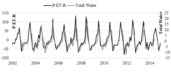
Figure 3 . Monthly measure of P − ET − R and the total water for the Ganga Brahmaputra basin.
Water Balances and Droughts and Floods
Lakshmi et al. (2018) have carried out a water balance analysis of large river basins, including the Ganga Brahmaputra. Figure 4, below, shows the variability in anomaly (departure from the average) for precipitation and total water storage (based on GRACE) in the upper part of each window. The maps underneath depict the spatial variability of the precipitation and GRACE total water anomaly for a wet month (July 2008) and a dry one (December 2011). It can be seen that in the wet month, the precipitation anomaly is mostly positive. In the dry month, most of the areas have a negative anomaly, but some areas have large positive anomalies. As for total water, there is abundance in July 2008 for all areas, whereas in dry months the total water anomaly is negative everywhere. Such basic temporal and spatial patterns that can be inferred from global and satellite data should be very valuable to local water management. In sum, in the absence of readily available guage data, applying global and satellite data can clarify (and help manage) local water and water quality challenges.
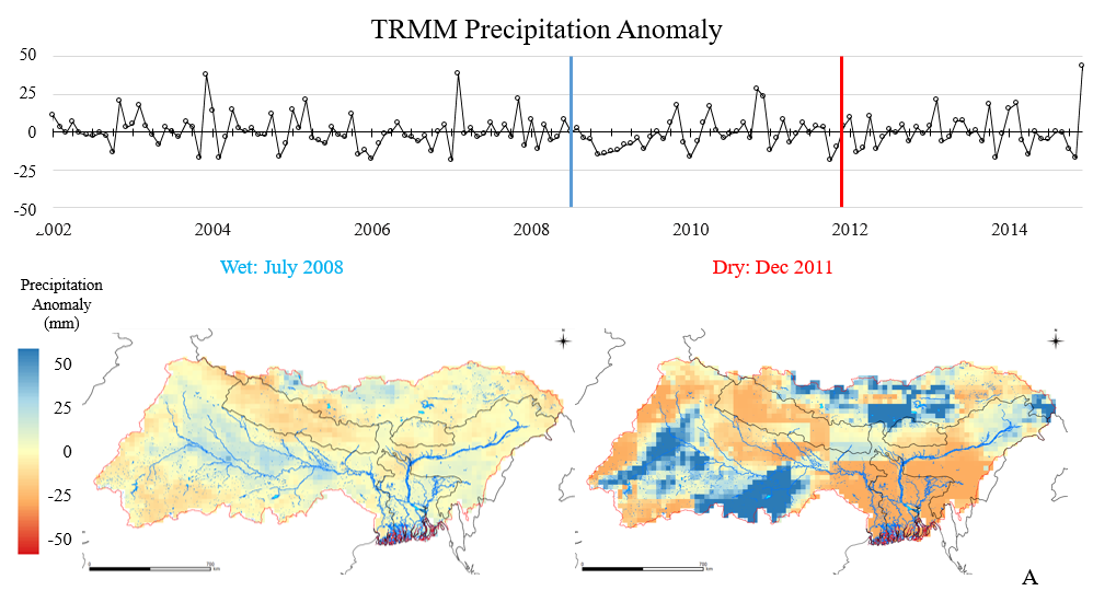
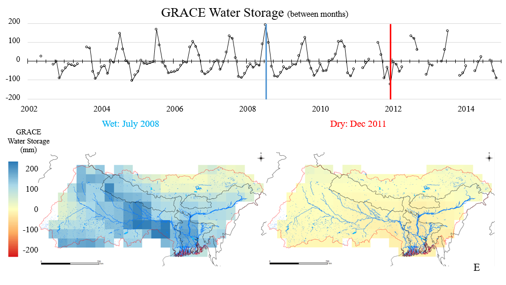
Figure 4. Precipitation anomaly and GRACE water storage anomaly for the Ganga Brahmaputra basin.
[1] The spatial resolution for precipitation (TRMM), runoff (GLDAS), and soil moisture (0–2m, GLDAS) is 0.25o; for ET (MODIS) it is 0.05o; and for total water (GRACE) it is 1o.
Venkataraman Lakshmi is a professor of Engineering Systems and Environment at the University of Virginia. His research interest are catchment hydrology, satellite data validation and assimilation, field experiments, land-atmosphere interactions, satellite data downscaling, vadose zone and water resources.
References:
J. Alcamo, M. Florke, and M. Marker, “Future Long-Term Changes in Groundwater Resources Driven by Socio-Economic and Climatic Changes,” Hydrological Sciences Journal 52, no. 2 (2007): 247–75.
Nigel W. Arnell, “Climate Change and Global Water Resources,” Global Environmental Change – Human and Policy Dimensions 9, supplement 1 (1999): S31–S49.
M. Herrera-Pantoja, and K. M. Hiscock, “The Effects of Climate Change on Potential Groundwater Recharge in Great Britain,” Hydrological Processes 22, no. 1 (2008): 73–86.
R.W. Howarth et al., Clean Coastal Waters: Understanding and Reducing the Effects of Nutrient Pollution, (Washington, DC: National Academy of Sciences, 2000).
G.J. Huffman, D. T. Bolvin, E. J. Nelkin, D. B. Wolff, R. F. Adler, G. Gu, Y. Hong, K. P. Bowman, and E. F. Stocker, “The TRMM Multisatellite Precipitation Analysis (TMPA): Quasi-Global, Multiyear, Combined-Sensor Precipitation Estimates at Fine Scales,” Journal of Hydrometeorology 8, no. 1 (2007): 38–55.
C.O. Justice et al., “The Moderate Resolution Imaging Spectroradiometer (MODIS): Land Remote Sensing for Global Change Research,” IEEE Transactions on Geoscience and Remote Sensing 36, no. 4 (1997): 1228–49.
C.O. Justice et al., “An Overview of MODIS Land Data Processing and Product Status,” Remote Sensing of Environment 83, no. 1–2 (2002): 3–15.
Zbigniew W. Kundzewicz, Luis José Mata, et al., “Freshwater Resources and Their Management,” chapter 3 of Climate Change 2007: Impacts, Adaptation and Vulnerability. Contribution of Working Group II to the Fourth Assessment Report of the Intergovernmental Panel on Climate Change, ed. M. L. Parry, O. F. Canziani, J. P. Palutikof, P. J. van der Linden, and C. E. Hanson (Cambridge, UK: Cambridge University Press, 2007), 173–210.
Venkat Lakshmi, “Beyond GRACE: Using Satellite Data for Groundwater Investigations,” Groundwater 54, no. 5 (2016): 615–18.
Venkat Lakshmi, Jessica Fayne, and John Bolten, “A Comparative Study of Available Water in the Major River Basins of the World,” Journal of Hydrology 567 (2018): 510–32, https://doi.org/10.1016/j.jhydrol.2018.10.038.
Santosh Nepal and Arun Bhakta Shreshtha, “Impact of Climate Change on the Hydrological Regime of the Indus, Ganges and Brahmaputra River Basins: A Review of the Literature,” International Journal of Water Resources Development 31, no. 2 (2015): 1–18.
Taikan Oki and Shinjiro Kanae, “Global Hydrological Cycles and World Water Resources,” Science 313, no. 5790 (2006): 1068–72.
Kenneth E. Mitchell et al., “The multi-Institution North American Land Data Assimilation System (NLDAS): Utilizing Multiple GCIP Products and Partners in a Continental Distributed Hydrological Modeling System,” Journal of Geophysical Research: Atmospheres 109 (2004), https://doi.org/10.1029/2003JD003823.
Qiaozhen Mu, Faith Ann Heinsch, Maoshen Zhao, and Steven W. Running, “Development of a Global Evapotranspiration Algorithm Based on MODIS and Global Meteorology Data,” Remote Sensing of Environment 111 (2007): 519–36.
Qiaozhen Mu, Lucas A. Jones, John S. Kimball, Kyle C. McDonald, and Steven W. Running, “Satellite Assessment of Land Surface Evapotranspiration for the Pan-Arctic Domain,” Water Resources Research 45, no. 9 (2009), W09420, https://doi.org/10.1029/2008WR007189.
Shilong Piao et al. , “The Impacts of Climate Change on Water Resources and Agriculture in China,” Nature, 467, no. 7311 (2010): 43–51.
Ragab Ragab and Christel Prudhomme, “SW–Soil and Water: Climate Change and Water Resources Management in Arid and Semi-Arid Regions: Prospective and Challenges for the 21st Century,” Biosystems Engineering 81, no. 1 (2002): 3–34.
Len Ritter, Keith Solomon, Paul Sibley, Ken Hall, Patricia Keen, Gevan Mattu, and Beth Linton, “Sources, Pathways, and Relative Risks of Contaminants in Surface Water and Groundwater: A Perspective Prepared for the Walkerton Inquiry,” Journal of Toxicology and Environmental Health, part A, 65 (2002): 1–142.
Matthew Rodell, Isabella Velicogna, and James S. Famiglietti, “Satellite-Based Estimates of Groundwater Depletion in India,” Nature 460, no. 7258 (2009): 999–1002, https://doi.org/10.1038/nature08238.
P.K. Roy, N. R. Samal, M. B. Roy, and A. Mazumdar, “Integrated Assessment of Impact of Water Resources of Important River Basins in Eastern India under Projected Climate Conditions,” Global NEST Journal 17, no. 3 (2015): 594–606.
Bridget R. Scanlon, Kelley E. Keese, Alan L. Flint, Lorraine E. Flint, Cheikh B. Gaye, W. Michael Edmunds, and Ian Simmers, “Global Synthesis of Groundwater Recharge in Semiarid and Arid Regions,” Hydrological Processes 20, no. 15 (2006): 3335–70.
Keith Schilling and You-Kuan Zhang, “Baseflow Contribution to Nitrate-Nitrogen Export from a Large Agricultural Watershed, USA,” Journal of Hydrology 295, no. 1–4 (2004): 305–16.
Pratap Singh, Manohar Arora, and N. K. Goel, “Effect of Climate Change on Runoff of a Glacierized Himalayan Basin,” Hydrological Processes 20, no. 9 (2006): 1979–92.
B.D. Tapley, S. Bettadpur, M. Watkins, and C. Reigber, “The Gravity Recovery and Climate Experiment: Mission Overview and Early Results,” Geophysical Research Letters 31, no. 9 (2004), https://doi.org/10.1029/2004GL019920.
Richard G. Taylor et al., “Ground Water and Climate Change,” Nature: Climate Change 3, no. 4 (2012): 322–29.
David Tilman, Kenneth G. Cassman, Pamela A. Matson, Rosamund Naylor, and Stephen Polasky, “Agricultural Sustainability and Intensive Production Practices,” Nature 418 (2002): 671–77.
V.M. Tiwari, J. Wahr, and S. C. Swenson, “Dwindling Groundwater Resources in India from Satellite Gravity Observations,” Geophysical Research Letters 36, no. 18 (2009): 184–201, https:/doi.org/10.1029/2009GL039401.
Charles J. Vorosmarty, Pamela Green, Joseph Salisbury, and Richard B. Lammers, “Global Water Resources: Vulnerability from Climate Change and Population Growth,” Science 289, no. 5477 (2000): 284–88.