Lint Barrage is an Assistant Professor of Economics and Environmental Studies at Brown University, and she will be joining the University of California at Santa Barbara Department of Economics in the Fall of 2019. She gave a talk at the Darden Business School about climate risk beliefs and coastal housing markets, focusing on the flood risks associated with sea-level rise. A student of Nobel laureate William Nordhaus, Barrage studies the economic impact of climate change, as well as the effectiveness and optimality of policy tools (like a carbon tax) at hand. We spoke with her.
What are the projections of climate-change induced sea-level rise, and to what extent is the United States exposed to it?
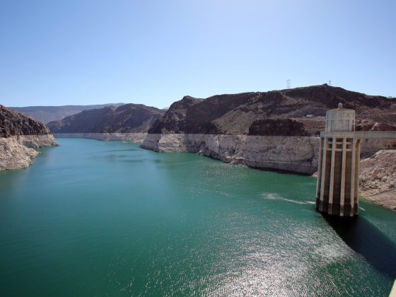
The United States is highly exposed to sea-level rise, both geographically and in terms of assets at risk. Standard projections range from 1 to 4 feet of global sea-level rise by 2100 due to the combined effects of thermal expansion of the oceans and the melting of glaciers and ice sheets.[i] Because of the inherent difficulty in modeling processes such as ice-sheet dynamics, there remains considerable uncertainty over this range, and scenarios of up to 6 or even 8 feet of sea-level rise cannot be ruled out.[ii] To put these figures in perspective for the United States, 3.3 feet of global sea-level rise could inundate an estimated 13,000 square miles—corresponding roughly to the combined land areas of Connecticut, Rhode Island, and Massachusetts—and expand high-risk flood zone areas by 40%.[iii]
Economically, these impacts have the potential to be highly consequential. Currently, around 40% of the US population is estimated to live in shoreline-adjacent counties. While people can move, vulnerable structures may become stranded assets in an almost literal sense. By some estimates, over $1.4 trillion of real estate (valued at 2014 prices) is located within 1/8th of a mile of the US coastline.[iv] Of course, not all of these assets are vulnerable to sea-level rise due to significant regional variation in elevation, sea-level trends (local trends may differ significantly from global averages), construction development, adaptation, and many other factors. Overall, however, sea-level rise poses a significant economic risk to the United States.
Why study the housing market to learn about climate change? And what does your analysis tell us?
Housing markets are interesting because they reflect people’s beliefs about the future. In deciding where to live and how much to pay for a house, people typically consider both the flow of costs and benefits of living in a particular home, and the expected future resale value of the house. This is why, for example, the exact same housing unit in Arlington, Virginia, might sell for a higher price the day after Amazon’s HQ2 announcement than the day before. By the same token, consider two otherwise identical homes—same area, same views, same school district, and so on—that differ only in their exposure to sea-level rise (due to, for example, differences in elevation). We would expect the less-exposed house to fetch a “safety premium,” or, equivalently, the more-vulnerable house to suffer a “risk penalty.” This kind of efficient risk pricing is important, for example, to guide new housing investment to favor safer areas and structures on the margin. Since sea-level rise is relatively slow and anticipated, we can greatly minimize its economic costs through anticipatory adaptation—at least in theory. Whether markets end up directing resources appropriately in that direction depends on whether prices reflect risks accurately.
In reality, the data suggest a very mixed picture. A recent national study by Bernstein, Gustafson, and Lewis (2018) finds a substantial negative effect of sea-level rise risk on coastal housing prices, but only in the non-owner-occupied housing market segment.[v] For owner-occupied coastal homes, the authors do not detect such a risk penalty. A notable exception occurs in parts of the country where people are the most worried about climate change, according to estimates from the Yale Project on Climate Change Communications (YPCC). In places with high concern, even owner-occupied homes show a substantial sea-level rise penalty. Other studies have documented similar patterns. For example, Severen, Costello, and Deschenes (2018) find that agricultural land prices reflect climate change forecasts to a higher degree in areas with stronger climate change beliefs.[vi] In Barrage and Furst (2019), we also find that there has been relatively less new housing construction in sea-level rise–exposed areas with higher estimated concern over climate change.[vii]
These results are, in many ways, intuitive—housing markets will respond to risks only to the extent that people believe in them. Housing is unique compared to many other assets (stocks, commodities, etc.) in that there is no short-sale market for homes at the detailed geographic scale over which sea-level rise exposure varies. If the price of another asset – say the stock of a trendy company – seems too high relative to its fundamental value, traders can short-sell this stock, which intuitively means they bet that its price will go down in the future. This mechanism allows the stock market to aggregate beliefs about the future value of the stock both from people who are optimistic and from those who are concerned. For individual homes, no such market mechanism exists. As a result, housing prices reflect mainly the buyer’s beliefs, even if they differ from the beliefs of other market participants or the scientific forecast.
This is precisely what my coauthor Laura Bakkensen and I explore in the research I presented at Darden.[viii] We conducted a door-to-door survey campaign in Rhode Island to better understand households’ perceptions of their own flood risk. One of our main findings is that people’s beliefs vary widely, and that those who live in official FEMA high-risk flood zones are (on average) significantly less concerned about coastal flood risks than their neighbors who live slightly further inland. We do not find evidence that this difference is driven by differences in beliefs about FEMA assistance in case of a flood event (which is actually very limited), or about flood damages, or about insurance reimbursements in case of a flood. Within our sample, the majority of coastal residents also perceive lower flood risks to their homes compared to the figures we obtain from a coastal inundation model. Of course, there are many other factors involved, and we also find that coastal residents have significantly higher amenity valuations for waterfront living, as one might expect. Nonetheless, even controlling for these valuations, our results are at least consistent with the possibility that people sort into high-risk housing in part based on disproportionately low flood-risk beliefs, thus potentially dampening the capitalization of flood and climate risks into housing prices, at least for now.
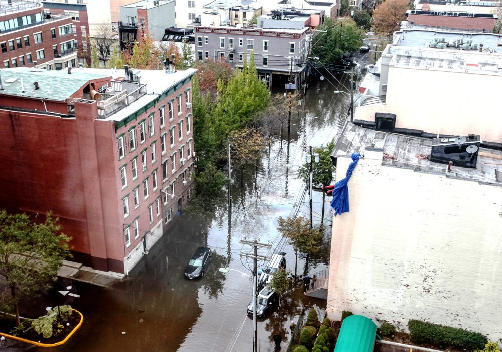
Does your work have any policy implications, and what does it tell you about the prevailing flood insurance?
First and foremost, the results highlight the critical importance of providing better flood and climate risk information. FEMA produces flood maps for most coastal communities in the United States, which are an excellent resource, but they suffer from significant shortcomings. One is that a substantial number of the maps are out of date: one out of six maps was over 20 years old (when we checked in 2017). This was the case, for example, in New York City when Hurricane Sandy struck in 2016—some local flood maps had not been updated since 1983.[ix] Another issue is that even up-to-date maps provide information only on current flood risks (and are often based on backward-looking risk assessment). In order to make truly informed housing market decisions, people and investors also need forward-looking information on how flood risks are expected to evolve in the future. Some leading communities, including New York City and parts of Rhode Island, have started producing such maps.[x] But this kind of information really should be produced and disseminated at a broader scale if we want markets to be operating and responding efficiently to natural hazards.
Another policy issue is, of course, the National Flood Insurance Program (NFIP), which is the dominant insurer against flood risk in the United States. There are several concerns with how this market currently functions. The fraction of people who take up insurance is shockingly low. By some estimates, only around 30% of structures in FEMA high-risk flood zones have insurance policies,[xi] despite the fact that (i) insurance is technically mandatory for homes with federally insured mortgages, and (ii) insurance is available at subsidized rates for some of the homes in these areas. The availability of these subsidies, it must be said, is limited and depends on when a home was built, when a community received its first flood-risk rating, the ownership and insurance policy history, and other factors. There is also a checkered history of policy attempts at reforming NFIP and these subsidies, with the Biggert-Waters Act of 2012 introducing limitations, and the Homeowner Flood Insurance Availability Act of 2014 partially repealing those limitations. In theory, a law that requires full flood insurance based on each property’s real risk of flooding could ensure that housing prices reflect those flood risks correctly (if the law was perfectly enforced and insurance rates were set appropriately). In reality, there are serious distributional (not to mention political) concerns associated with this idea. For many Americans, housing equity is the largest asset in their savings portfolio. Any policy change that reduces housing prices is thus potentially problematic regardless of whether it represents a correction toward fundamentals. People may have stereotypes in their heads about coastal homes as millionaire mansions, but there are plenty of low-income folks who live in vulnerable homes.[xii] At the same time, the reality is that many homes’ fundamental values are being eroded by flood-risk increases, so that delaying the housing market response to these risks exposes owners and coastal communities to potentially sharp devaluations in the future.
In short, we need to take distributional concerns seriously, but we also can’t bury our heads in the sand, because the water is coming. We can minimize the economic cost disruptions from sea-level rise, but only if we understand the real risks and plan for what’s ahead.
[i] Jerry M. Melillo, Terese (T.C.) Richmond, and Gary W. Yohe, Eds., Climate Change Impacts in the United States: The Third National Climate Assessment (U.S. Global Change Research Program, 2014).
[ii] Andra J. Garner, Jeremy L. Weiss, Adam Parris, Robert E. Kopp, Radley M. Horton, Jonathan T. Overpeck, and Benjamin P. Horton, “Evolution of 21st Century Sea Level Rise Projections,” Earth’s Future 6, no. 11 (2018): 1603–15.
[iii] James E. Neumann, Sea-Level Rise & Global Climate Change: A Review of Impacts to US Coasts (Pew Center on Global Climate Change, 2000).
[iv] Ryan McNeill, Deborah J. Nelson, and Duff Wilson, “Water’s Edge—The Crisis of Rising Sea Levels,” Reuters Investigates (2014).
[v] Asaf Bernstein, Matthew Gustafson, and Ryan Lewis, “Disaster on the Horizon: The Price Effect of Sea Level Rise,” Journal of Financial Economics, forthcoming, 2018.
[vi] Christopher Severen, Christopher Costello, and Olivier Deschenes, “A Forward-Looking Ricardian Approach: Do Land Markets Capitalize Climate Change Forecasts?,” Journal of Environmental Economics and Management 89 (2018): 235–54.
[vii] Lint Barrage and Jacob Furst, “Housing Investment, Sea Level Rise, and Climate Change Beliefs,” Economics Letters (2019).
[viii] Laura A. Bakkensen and Lint Barrage, “Flood Risk Belief Heterogeneity and Coastal Home Price Dynamics: Going Under Water?” (working paper no. 23854, National Bureau of Economic Research, 2018).
[ix] Matthew Gibson, Jamie T. Mullins, and Alison Hill, “Climate Change, Flood Risk, and Property Values: Evidence from New York City” (working paper, Department of Economics, University of Massachusetts, 2017).
[x] “CRMC, URI Unveil Flood Maps for East Bay,” Rhode Island Coastal Resources Management Council, January 14, 2019, http://www.crmc.ri.gov/news/2019_0114_floodmaps.html (accessed Mar. 4, 2019).
[xi] Carolyn Kousky, Howard Kunreuther, Brett Lingle, and Leonard Shabman, “The Emerging Private Residential Flood Insurance Market in the United States,” Wharton Risk Management and Decision Processes Center (2018).
[xii] “The National Flood Insurance Program: Financial Soundness and Affordability,” Congressional Budget Office, September 1, 2017, CBO Publication 53028.